Mysteries on the Map is a series that highlights a different ghost town and how it contributed to the rich history of Nebraska. Running through the summer months, it pays tribute to the pioneers who endured incredible hardship and paved the way so that we can now enjoy the good life called Nebraska.
If you have suggestions or stories to share about a community that no longer exists, contact reporter Kristen Sindelar at Kristen.Sindelar@midwestmessenger.com.
Natural beauty anchored one-time northern Nebraska Community
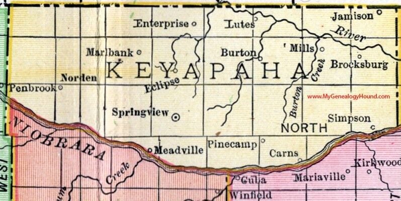
Taking the scenic route has a whole new meaning when trekking through Keya Paha County in extreme northern Nebraska. Even the map alludes to the beauty of this region, with road names like “Outlaw Trail Scenic Byway” designated for portions of Highway 12.
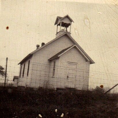
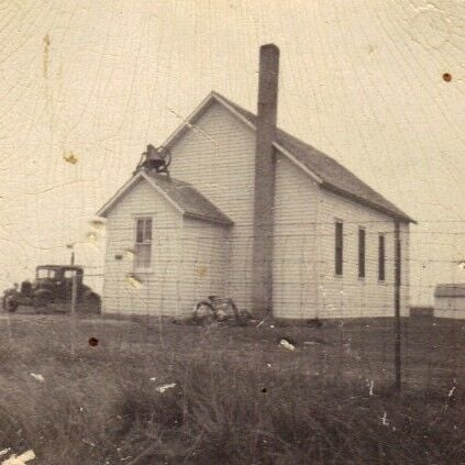
Meadville established along the northern banks of the Niobrara River in Keya Paha County.
Image from www.mygeneologyhound.com
Only by veering off the main road can you fully appreciate its grandeur.
You know you are near the Meadville Store and now Meadville Cultural and Historical Museum when you find the Meadville Road and Meadville Avenue conjunction.
The board of directors for the Meadville Cultural and Historical Society include in the back row Jason Appelt, Cameron Palmer and Rodney Palmer. In the front row are Ann Appelt, Harlin Welch Jr., and Diette Glenn.
Many of the early settlements, dubbed “towns” by the people who congregated there, are no longer given an ounce of recognition on a map. One such sleepy little hollow nestled in the far southeastern corner of Nebraska in Pawnee County was known as Mayberry.
The people of Mayberry were considered “settled and satisfied.”
Edwin Bredemeier loved his old town of Mayberry, Neb. He was standing by the back door of his home in this photograph taken in May 1999. Notice his reflection in the door’s windowpane.
Photo submitted by daughter Janet (Bredemeier) Coudeyras
Short-lived town of Nursery Hill served stagecoach travelers
Modern-day travelers crossing Otoe County in Nebraska are familiar with the towns dotting the map near Highway 2, from Nebraska City on the far eastern border to Palmyra on the west and Dunbar, Syracuse and Unadilla in between. But these settlements were nonexistent when pioneers first traversed the land in prairie schooners before Nebraska reached its statehood and the Civil War loomed on the horizon.
This map of Otoe County, Neb., shows the westbound trails of the 1860s.
Submitted photo
Many a westward-bound wagon train snaked along the Platte River on the Oregon Trail, but goods were often freighted on a more direct route called the Overland Trail. Freighters and drovers would cross the Missouri River near Nebraska City then follow this trail for a day before fording the Nemaha River to arrive at Nursery Hill.
Dennis Wendeln and Judy Moore shared valuable history about Nursery Hill, Neb., a stage station located 20 miles west of Nebraska City that flourished during the western migration of the late 1800s.
The Utley home was moved to Syracuse, Neb., and renamed “The Review Hotel.” This bird’s eye view photograph was taken from the top of a windmill in Syracuse.
Long before the river channel cut deeply from water erosion, a water-powered grain mill operated along the Nemaha River west of present-day Syracuse, Neb.
The trail through Nursery Hill was no longer needed to transport supplies westward when a railroad track was built on the east side of the Nemaha River. The town of Syracuse formed as a result.
Lowell: From boisterous boom town to peaceful farming community
You likely will not see Lowell, Nebraska on modern-day road atlases, but Google Maps will still take you to the ghost town’s remnants in northeastern Kearney County.
A blue and silver Nebraska State Historical Society marker oversees the intersection of Lowell and Carpenter roads, commemorating this boom town from the railroad days. Various accounts written about Lowell say that it sprang up overnight from the vast prairie and disappeared just as quickly.
An unidentified gentleman sits inside the courthouse located in Minden, Neb. The calendar behind him is dated Nov. 6, and those to the right show 1929. The calendar to the far right with the girl is from the Lowell State Bank. Hultquist believes that 1929 was the last year that the Lowell State Bank existed due to the stock market crash and ensuing Great Depression.
Lowell was the Kearney County seat, but its location in the northeastern corner of the county was not ideal when transportation was limited to walking on foot, riding on horseback or taking a horse and wagon.
Emporia once shipped thousands of cattle, hosted country school until 1990
A 21st century map of Holt County in Nebraska has many more road lines and less town dots than those maps from the Gilded Age, a time when the open prairie beckoned to ambitious frontiersmen and the railroad carried them westward to their fates.
As quickly as railroad tracks could be laid, communities sprang up alongside in tempo with the chugging of the trains. Over time, these establishments either grew into thriving towns or withered with the residents into dust.
Emporia was a railroad switch on the Nebraska and Western Railway Co. that ran from South Sioux City to O’Neill, Neb. It was located near the eastern border of Holt County.
Image from Galbraith’s Railway Service Map, Nebraska, 1897. Courtesy of Library of Congress State Map Collections.
The railroad was to dissect the town of Emporia, as shown by this map for Sections 34 & 35, Township 28 North, Range 9, West of the 6th P.M. in Holt County, Neb.
Gary Kratky has over 135 years of history documented in this Abstract of Title from the land that he owns in Holt County. Emporia once sat on his piece of property.
When Dist. No. 88 was rebuilt, the school was large enough for two teachers. Pictured are Emporia pupils and teachers, Sept. 1928-May 1929.
Front: Raymond Omey, Wilma Kirschmer, Dorothy Lampert, Arlo Watson, Joseph Beelaert, June Finley, Mildred Wiseman, Donald Cleveland, Gene Shaw, Herbert Kirschmer, Dorothy Kornock, Jeanne Finley, Martin Craig, Roberta Omey, Vern Retke, Agatha Beelaert, Helen Finley, Dorothy Alexander, Robert Watson, Zella Omey, Fay Finley, Leo Cleveland, Alfonso Beelaert, Lisle Grafft.
Back: Leland Finley, Edward Shaw, Eddie Williamson, Lawrence Haynes, Vern Cleveland, Selma Kirchmer, Florence Omey, Marie Beelaert, Margaret Retke, Lucille Retke, Thelma Grafft, Julia Beelaert, Miss Alma Harris of Page (teacher for grades 1-6), Miss Winifred Fogler of Orchard (teacher for grades 7-10), Bernard Kornock, Frank Beelaert, LaVern Finley, Eva Holliday, Beulah Friday, Gordon Finley, Minnie Williamson.
Submitted photo
kAmp55:E:@?2==J[ zCFEK’D 7@C>6C ?6:893@C 925 2EE6?565 9:89 D49@@= 2E t>A@C:2]k^Am
Mrs. Ruth Hansen of Inman, Neb. had 18 pupils in all grades, except for first, during the 1962-1963 school year at Emporia School Dist. No. 88.
Front: Steve Lampert, Janet Lampert, Jan Kornock, Trudy Rutherford, Debbie Allen, Nadine Ruther, Billy Hartigan, Leann Kornock and Chuck Lampert.
Back: Donelle Hartigan, Patricia Ruther, Joie Allen, Duane Shaw, Dennis Finley, Gloria Shaw, Tim Stelling, Mark Stelling, Larry Kornock and Mrs. Ruth Hansen.
Matt Panke On The Richman Ranch In Between 1890 & 1895, It Was Was Of Three Ranches In The Area. It Had A Horse Barn That Photo & Information Submitted By—Lamoin Meyer—Brule, Nebr. Had Room For About 8 Horses, & A Dipping Vat Which Was Warmed By A Steam Blower. The House Was Built Around 1905-1910 With Square Nails. There Were Only About 300 Acres Tillable Ground & The Rest Wast Prairie Grass. Horse Power Units Were Used For Threshing, It Was Located 9 Miles South Of Brule On Just A Trail. Ryal Meyer Now Lives There.
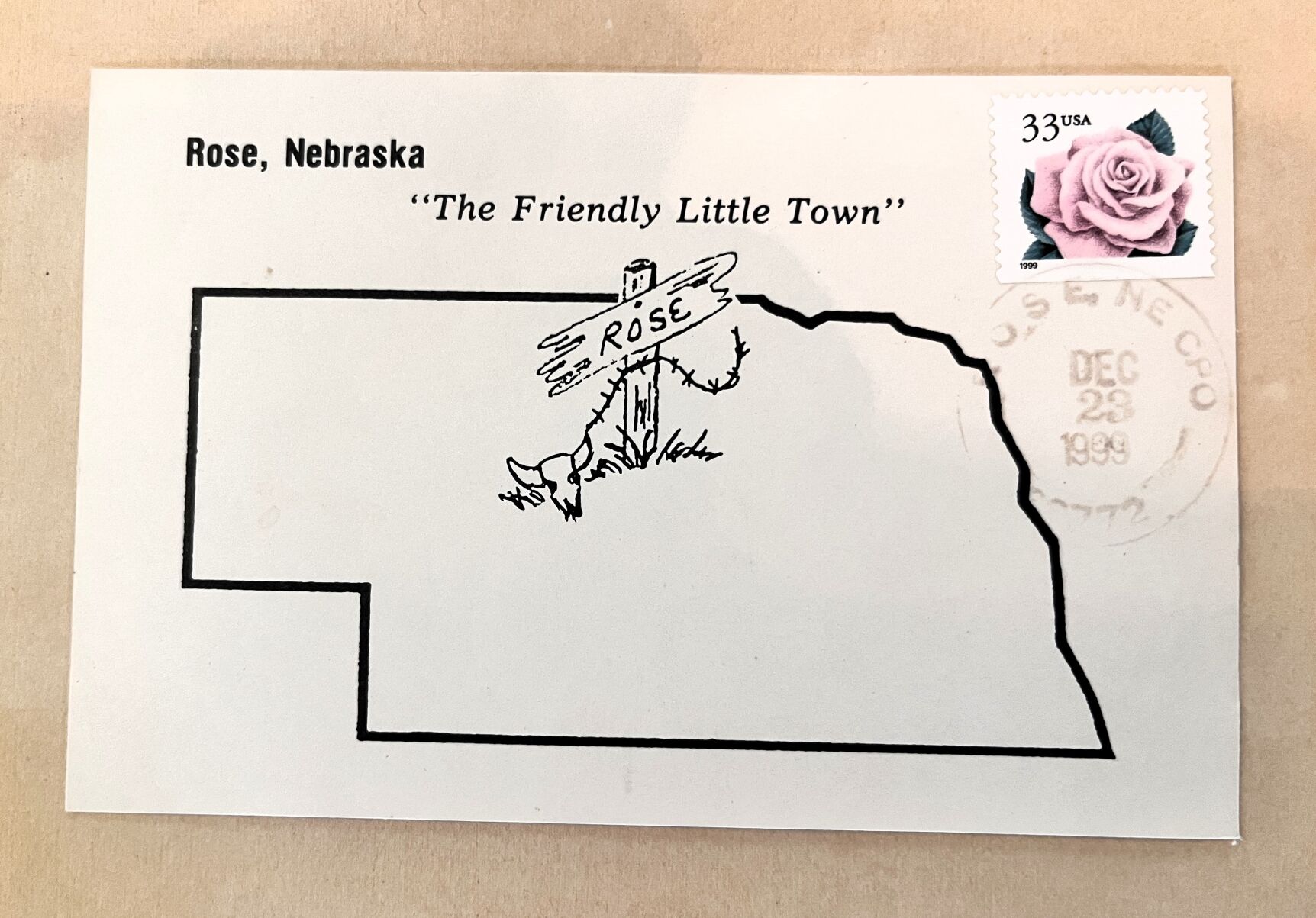
The Mysteries on the Map series began as a tribute to the people who formed those long-forgotten settlements in Nebraska now considered “ghost towns.” Upon the suggestion of a Midwest Messenger reader and family friend, I began researching Rose in Rock County. Little did I know that this project would turn from a mystery on the map into a history of this unincorporated community.
Located in southern Rock County, Rose was one of many small communities established in the early years of Nebraska settlement.
Image from mygeneologyhound.com
In early October, a group of former and present Rose residents met with me in the home of Audrey (Davis) Caskey in Bassett, Nebraska, to share their memories about Rose. When they heard the premise of the story was a “ghost” town, the room became animated.
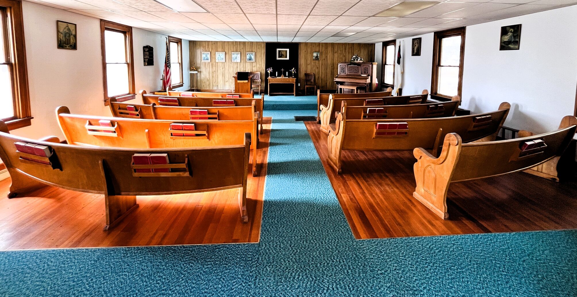
Janet Kuchera served as Officer in Charge of the Rose postal service for several years. Her three children—Clay, Peggy and Frank (being held)—are pictured in front of the post office area at the Rose Community Hall in this photo from the 1980s.
Residents faced 1880s floods, blizzards in Cedar County
If you were to study historical maps of Cedar County in Nebraska, you might be confused by the different names denoting a spot in northwestern Cedar County. Elm Grove, Strahmburg, Green Island and Aten all laid claim to the same general settlement, sometimes even being used interchangeably.
The area’s landscape has changed as frequently as the names, thanks to its location in a floodplain along the mighty Missouri River. Gavins Point Dam, built on the Missouri River in 1957 about four miles upstream from Aten, permanently affected the landscape but has effectively prevented catastrophic floods that were all too common for the early settlers.
Major flooding events were common along the Missouri River before manmade dams reduced the frequency and severity. The town of Green Island was completely wiped off the map by flooding in 1881 and replaced by Aten, as shown by this comparison of maps from 1879 and 1885.
These photos of “Uncle John Nelsons’ brick house” were found in a collection of Elsie (Nelson) Hermanson with a note dated June 2, 1972: “This house stood thru the flood of 1881—when the entire village of Green Island was swept away. Several people congregated here and were saved. Flood waters and ice chunks came up, even with the up-stairs windows.”
Nohr brothers Merle, 9, Dan, 7, and Floyd, 11, play outside the southeast corner of the old Parker Hotel, where the Nohr family resided in Aten, Neb. This photo was taken about 1919.
The large barn on the Nohr family farm in northwestern Cedar County, Neb., was built for dances and agriculture. The barn was constructed in 1918 and 1919, with the top specifically designed for dances. Lawrence Welk performed there, as did many other entertainers through the years.
The large barn on the Nohr family farm in northwestern Cedar County, Neb., was built for dances and agriculture. The barn was constructed in 1918 and 1919, with the top specifically designed for dances. Lawrence Welk performed there, as did many other entertainers through the years.
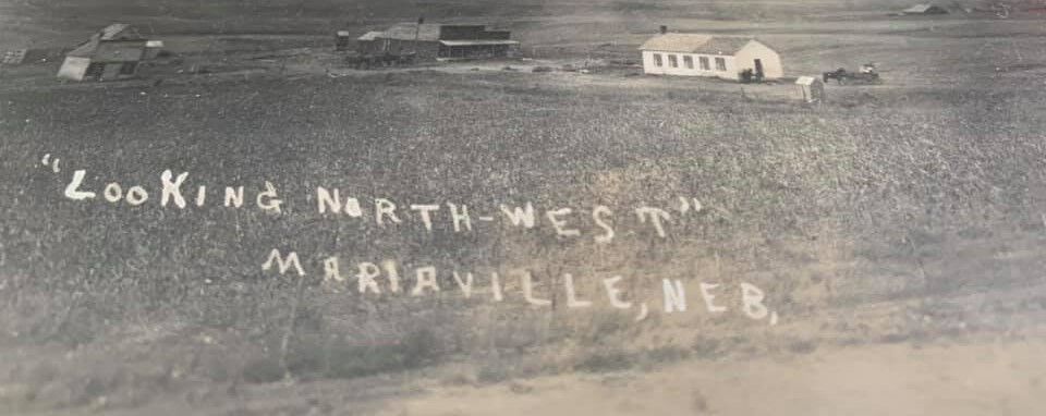
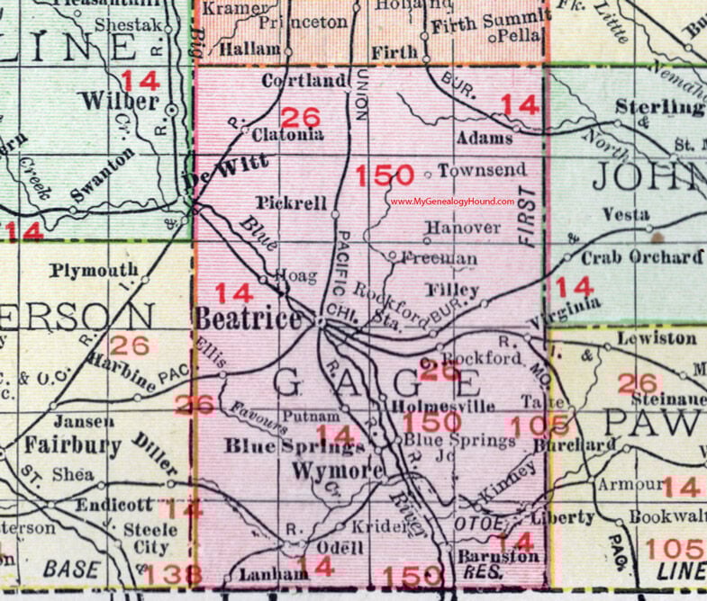
Mariaville: Little Rock County town was big on hospitality
Looking at a map of Rock County in Nebraska, you may not realize that it was once part of its sister county to the west, Brown County. Or that 18 towns once filled this cattle country. Or that an American outlaw frequented the region, receiving the same hospitality as any other wary traveler to Mariaville, Neb.
Thomas Peacock is the connecting thread of all these Rock County tales.
The community of Mariaville was located about 15 miles northeast of Bassett, as shown on this 1912 map of Rock County, Neb.
In a time before automobiles made travel easy, the few businesses in Mariaville provided the essential products and services to the families who homesteaded in this community.
A historical map of Nebraska from the 1800s shows a spider web of railroad lines dissecting the state. One line of the Chicago, Burlington & Quincy Railroad (CB&Q) traversed the rugged Nebraska terrain into the southeastern corner of Gage County to the whistle stop town of Kinney.
Here was a hub of commerce for grain and livestock.
The Ghost Gang found refuge in a house at the old site of Kinney, Neb., until the raid of Nov. 30, 1934. Maurice Denning, leader of the Ghost Gang, became the number one missing public enemy.
Brian Beerman, who was born and raised in Omaha spent years researching records about Denning and the Ghost Gang for accurate information to write his book. “Nebraska’s Missing Public Enemy: The Last of the Ghost Gang” was published in 2019.
According to some, Freedom, Nebraska, was named after another post office in the area that was established shortly after the Civil War.
Whereas the town of Freedom grew from a post office to a supply and entertainment hub, the post office location in Equity, another Frontier County ghost town in southwestern Nebraska, transformed into a courthouse.
William H. and Margret Allen moved from Michigan to Nebraska and eventually homesteaded in Frontier County. William served as judge of Frontier County.
In 1989, members of the Frontier County Historical Society erected 16 monuments throughout the county commemorating discontinued post offices. Pictured in front of the Allen log cabin are (from left to right) Waltz Betz, Marlyn Wolf, Charles Mousel, Amos Jurjens, Ken Phillips, Alfred Hinton and Truman Barrett.
Towns of Freedom, Equality reflect hopes of early settlers
Editor’s Note: This is part one of a two-part series on ghost towns Freedom and Equality in Frontier County, Nebraska.
Looking at a map of Frontier County in southwestern Nebraska, you can see many more towns dotting the landscape than now. Of the 16 localities on the 1912 map of Frontier County, only four remain 110 years later.
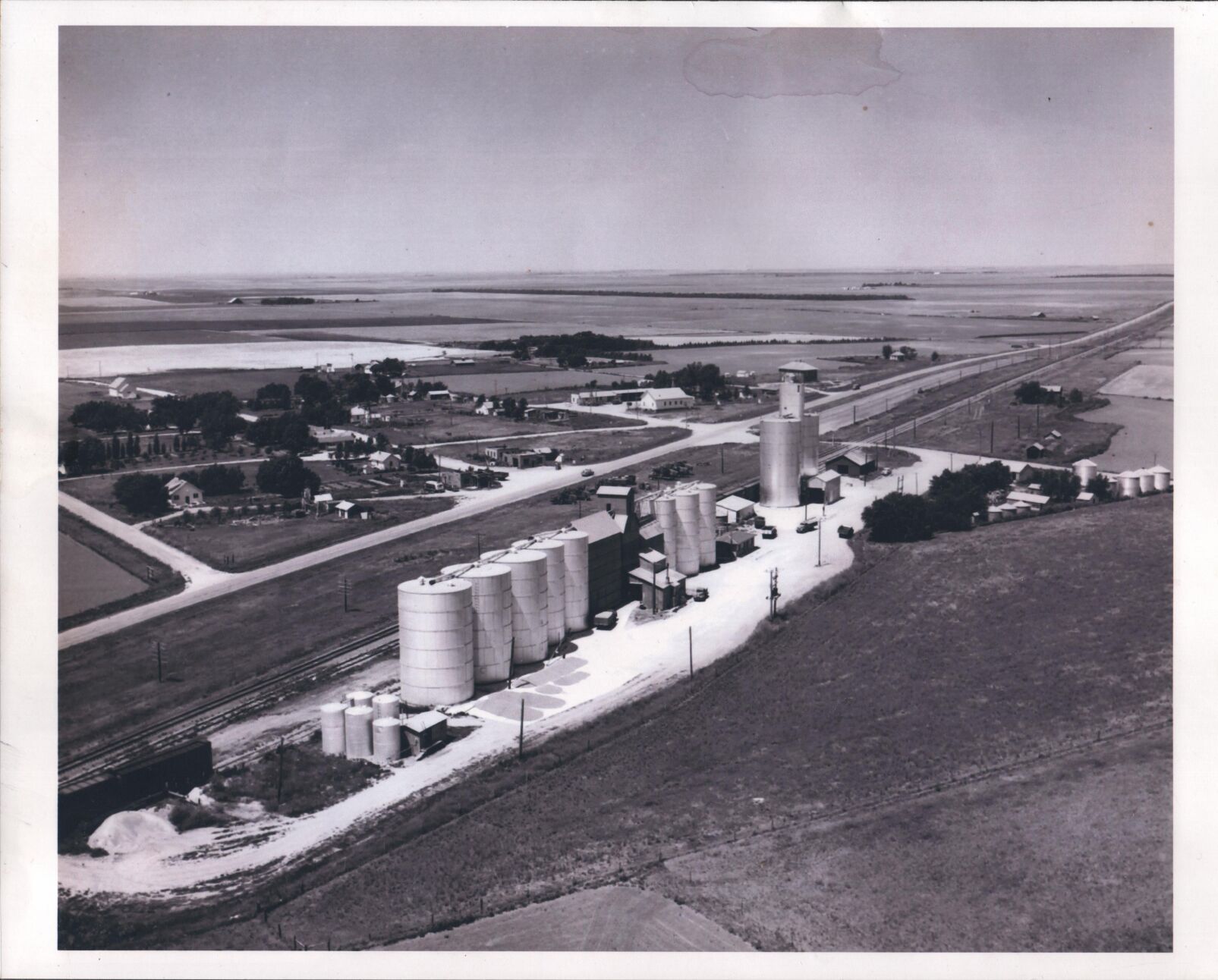
Looking at a map of Box Butte County, you can still find Berea, Nebraska, at the crossroads of Highway 2 and Highway 385 right between Hemingford and Alliance. Occupied homes still breathe life into this unincorporated community whose pulse beats to the rhythm of the parallel railroad tracks.
Berea was first documented in 1890, according to a history of Berea written in 2004 by a former resident, Kenneth Von Bargen.
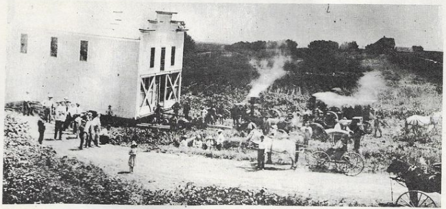
Berea, Neb., began with the railroad in the late 1880s and continued to thrive into the mid-1900s. This photo shows the Farmers Union Station around 1940.
Trains transported people and mail to the depot in the early years, then later hauled grain and potatoes out of Berea, Neb. The grain elevator is still in use today. Photograph is from 1958.
In Emerick, Nebraska, young couples had challenging start
Looking at a map of Madison County in Nebraska, you no longer see the marker for a town called Emerick. But if you drive on the blacktop 9 miles south of Meadow Grove, you pass by remnants of this pioneer village.
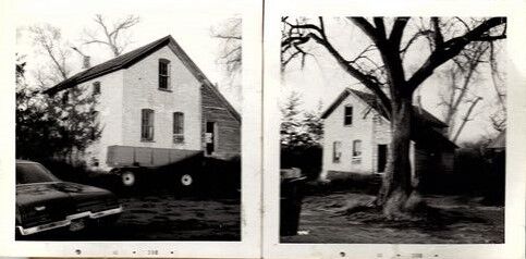
The gated Emerick Cemetery stands proudly atop a flat hill, active to this day and kept in top shape by the descendants of those who founded Emerick. One would hardly guess that the large, white house nearby was built in 1899 and housed one of the first families to the area.
The first mercantile store in Emerick, Neb., also served as the post office and a residence. The trees next to the store were part of the 40-acre timber claim.
The Methodist Church at Emerick, Neb., was built in 1891 and served the community for three decades before being moved. It is now a residence just north of Highway 275 and Meadow Grove.
My grandpa often tells stories about our family history, including the little town that once stood where his grandfather established a homestead in 1877. I began to wonder how many other ghost towns once dotted the Nebraska prairie, now simply mysteries on the map. Turns out, every single county across the state has lost a piece of history, a community that was instrumental in establishing Nebraska.
The first school at Emerick, Neb., was larger than most at the time.
Submitted photo
As a sort of road trip to the past, each month through the summer we will highlight a different place and how it contributed to the rich history of Nebraska. Mysteries on the Map pays tribute to the pioneers who endured incredible hardship and paved the way so that we can now enjoy the good life called Nebraska.
Caring community club continues in former railroad town
Precinct 19 in southwestern Cedar County in Nebraska is mapped out with the town of Randolph cornered in the bottom left and the railroad track halving the precinct diagonally. Not long ago, though, another town flanked these same railroad tracks.
Wareham, Neb., was established along the railroad tracks of Precinct 19 in southern Cedar County, Neb.
Image adapted from NE GenWeb Project
Located 4 miles east of Randolph and 3 miles west of Belden, Wareham, Nebraska was the definition of a railroad town. It was started by the Great Northern Railroad in 1904 and lived a short yet prosperous life along the Pacific Shortline that angled through from Sioux City, Iowa toward O’Neill, Nebraska.
This baseball uniform was worn by John Raymond Gubbels of Wareham, Neb. His grandson, Tim Gubbels, donated it to the Cedar County Historical Museum, located in Hartington, Neb.
The Wareham Club still meets regularly on the last Thursday of the month. Members include Rosemary Nordhues, left, Jean Buell, Betty Gross and Joan Lackas. Not pictured: Berdine Brunssen and Laura DeLong.
As the Fourth of July nears, a nationwide celebration reverberates from coast to coast in anticipation of America’s 250th birthday. In Nebraska, another lesser-known place also has an upcoming milestone.